Safe and secure payments using Abraa safe trade systems
 Product Specification
| Condition | New |
| Brand | HUAXIAMASTER |
| Warranty | YES |
| CNC | Yes |
Product Descriptions
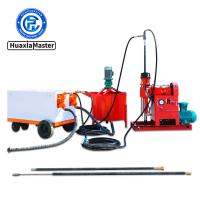
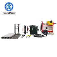
- Introduction to ADMT Series Intelligent Imaging Water Finder
ADMT series intelligent imaging water finder is a new generation of intelligent geophysical exploration instrument. It carries the host, TT sensor, MN electrode, battery and wireless communication module in an ABS tube. It can be wirelessly connected to mobile phones, tablets and dedicated control hosts for control and automatic mapping. The intelligent imaging water finder has a built-in lithium battery and can measure as soon as it is turned on. There is no connection, and it can achieve full wireless operation. It can quickly find groundwater by measuring the changes in underground electromagnetic field TT or electric field to invert the changes in underground resistivity. The data acquisition module and digital filtering intelligent algorithm have strong anti-interference, accurate data, stable and reliable, and adjustable depth. The results of two-dimensional, three-dimensional and curve effect diagrams can be quickly drawn on site. At present, intelligent imaging water finders have been widely used in resource exploration such as water, mineral exploration and geothermal hot springs, and are also used for dam pipe burst detection, underground buried objects such as cavities and pipelines, etc.
- Features of ADMT Series Intelligent Imaging Water Finder
2.1 Completely wireless: The stick integrates MN and TT signal inputs (the lowest configuration does not include TT), and data signal collection is achieved without any wiring; the instrument has built-in high-performance lithium batteries, Bluetooth or Wi-Fi communication, and the human-machine interface is realized completely wirelessly.
2.2 One-button simple measurement: The instrument has only one power button, no other buttons are required, which improves usage. The top power button is integrated with a surround indicator light and the bottom has a power interface.
2.3 Efficient transmission: The advanced WiFi connection technology greatly improves the data transmission efficiency and can work by connecting to a mobile phone.
2.4 Adjustable measurement depth: After the smart imaging water finder is connected to the mobile phone, the measurement depth can be quickly adjusted in the APP. You can adjust the depth as deep as you want, which greatly saves measurement time. In addition, the new offline measurement function improves the user experience while effectively avoiding the influence of external factors such as electromagnetic interference that may be encountered in real-time measurement on the data, and the measurement results are more accurate and reliable.
2.5 Quick mapping on mobile phone: No need to wait after measurement is completed, the APP will generate underground profile on site, through which you can determine the location and depth of groundwater and estimate the amount of water produced. You can view and analyze the map online for free 24 hours a day. Artificial intelligence continuously learns and grows based on user feedback, and it becomes more and more accurate in drilling wells and finding water, providing a reliable basis for drilling wells and finding water.
 \
\